
Exploiting Data to Support UK Search and Rescue
Dr Josh Hoole, Dr Oliver Andrews, Dr Steve Bullock
Introduction
Various UK organisations provide 24/7 Search and Rescue (SAR) capability year-round across land, sea and air. Data analytics provides a key route to supporting SAR operations and aerospace system design in the future.
Aims of the Project
The aim of this project was to explore what data is available to capture the variability present in SAR operations (including mission characteristics and weather) to help support the future design of aerial systems to support SAR. This aim was to be achieved using the following objectives:
Engagement with search and rescue organisations to establish:
- Availability of data for characterising SAR mission profiles
- Perceptions on developing Unmanned Aerial Vehicles (UAVs or ‘drones’) to support SAR
Data fusion across asset tracking data to characterise SAR mission profiles:
- Exploitation of aircraft and vessel trajectories
- Combining mission profiles with meteorological data
This project therefore lay at the exciting and valuable intersection between data science, aerospace systems, weather and climate analysis and SAR.
Results
To date on the project, the following activities have been performed supported by the Seedcorn Funding:
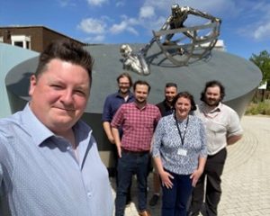
Data Workshop with the Royal National Lifeboat Institution (RNLI)
A one-day workshop was held with the RNLI Data team at the RNLI College in Poole. Within this workshop, areas of interest and ideas were shared spanning the exploitation of data for mission analysis, future planning and the use of computer vision to support lifesaving activities. The University of Bristol team were simply amazed at the large amount of data-driven work performed by the RNLI and look forward to establishing stronger links between the RNLI and research institutions in the future (see contact details below).
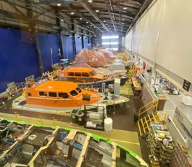
There was also a tour of the RNLI’s training and lifeboat manufacturing facilities as part of the workshop to provide context to the RNLI’s activities. The Bristol team were overwhelmed by the vast and diverse capabilities present in a single location and thoroughly recommend a tour of the RNLI College and All-weather Lifeboat Centre.
Initial Assessment of Vessel Tracking Data
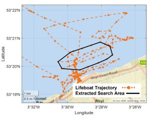
Maritime vessels are equipped with real-time tracking capability via Automatic Identification System (AIS) installations. Historic AIS data provides vessel trajectories which can be post-processed to characterise the mission performed. Building on prior work in the literature, an initial investigation into processing the AIS trajectories of RNLI lifeboats has been performed using data sourced from MarineTraffic. Using simple algorithms, AIS trajectories can be processed to identify the occurrence of lifeboat search manoeuvres and generate characteristics regarding the search operation (e.g. search time, search area, etc.). It is intended that such characteristics can be used in the future to support the post-mission reporting performed by the RNLI.
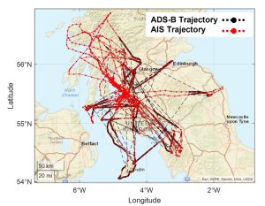
Data Fusion to Enhance SAR Helicopter Tracking Data
A large number of aerospace vehicles are also equipped with real-time tracking capability via Automatic Dependent Surveillance-Broadcast (ADS-B) equipment. However, as a line-of-sight system, ADS-B derived trajectories are often lacking in the regions where SAR operations take place, such as at low altitude, close to obstructions or out at sea. SAR helicopters are also equipped with AIS equipment, permitting ADS-B and AIS data sources to be fused to greatly increase the coverage of SAR helicopter trajectories. The ADS-B/AIS fused trajectories can then be further processed to generate mission characteristics as for the maritime vessel trajectories.
Future Plans
Exploitation of Meteorological Data Products
Following completion of the SAR mission characterisation via AIS and ADS-B data sources, the project will intend to couple the trajectories to meteorological data products to fully characterise the SAR operational environment. This level of data fusion could support automated post-mission reporting, draw correlations between the search characteristics and operating environment, as well as support future planning with respect to the impacts of climate change on UK SAR operations.
Engage further with Inland SAR Organisations (PhD projects)
So far, the project has focused on maritime SAR. Future work will engage with inland SAR organisations to a greater extent and initial links have been formed with the relevant organisations. Dr Steve Bullock has successfully secured funding for two PhD students in the area of SAR planning for UAVs and these project will aim to leverage the expertise from the SAR connections made during this project.
Future SAR Data Research Partnerships
The workshop with the RNLI highlighted a significant number of data-centric avenues that could be pursued within future research projects, including aspects of machine learning, computer vision, weather and climate, along with mission analysis. A future workshop is planned, and researchers from across the data community at the University of Bristol are encouraged to participate, so please get in touch via the contact details below. The University of Bristol team are also very keen to explore collaborative partnerships within this area with other research institutions (GW4 and beyond) and SAR organisations. Please send any expressions of interest regarding future opportunities to the contact details below.
Contact Details Dr Josh Hoole, Department of Aerospace Engineering, University of Bristol, josh.hoole@bristol.ac.uk