Successful PGR Seed Corn Awardees 2021-2022

The Jean Golding Institute’s Seed Corn Scheme

The Jean Golding Institute are pleased to announce the Post Graduate Researcher Seed Corn Funding awards. Every year we provide seed corn funding to Post Doctoral Researchers, but this year we are pleased to also be able to provide funding to small-scale projects for Post Graduate Researchers at the University of Bristol, which we hope will help to develop their projects further. Through our Seed Corn Funding Scheme, we aim to support initiatives to develop interdisciplinary research in data science (including Artificial Intelligence) and data-intensive research. 

The Winners

Abdelwahab Kawafi is doing a PhD in Physiology working on supervised learning for computer vision mainly on CT scans and microscopy. This seed corn project is in material science, working on particle tracking of 200nm colloids using super-resolution confocal microscopy for the analysis of the glass transition.

Ahmed Mohammed is a postdoctoral researcher in the field of water engineering. His PhD research investigates precipitation forecasting at high spatial and temporal scales using various methods such as numerical weather prediction, optical flow-based models, and deep learning techniques.

Ahmed and Hongbo are working together on a project called “Performance evaluation of a deep learning model in short-term radar-based precipitation nowcasting”. Radar precipitation data will be used in this project to refine an existing convolutional neural network precipitation nowcasting model in order to improve end-to-end rainfall nowcasting model performance and compare it to optical flow-based models and the Eulerian persistence baseline model.

Hongbo Bo is a Ph.D. student in computer science. His research focuses on social network analysis by using graph data mining techniques like graph neural networks, continual learning, and contrastive learning methods.


Anuradha Kamble is a Postgraduate Research student at Bristol Composite Institute in the Department of Aerospace Engineering. Prior to this, she had three years of industrial experience in the commercial HVAC (Heating Ventilation and Air Conditioning) and EV (Electric Vehicle) industries. Recent discoveries in materials science have seen growing applications of machine learning for materials discovery by leveraging the experimental data generated over many years in different studies. Her research project is titled “Exploiting the deep learning technique to study a novel nano-modified polymer composite.” The goal of this study is to implement deep learning techniques to investigate the most suitable parameters e.g., material composition, processing temperature, and time, to study a nano-modified polymer composite. The objective of this project is to improve the generalizability of deep learning model so that it can be widely applicable to any novel materials developed in the University of Bristol. Similar applications in the field of bio sciences will be explored by collaborations with other universities across the UK.

Tian Li is a PhD student studying Physical Geography in the School of Geographical Sciences. Her work focuses on using Earth Observation techniques to study the polar glaciers. Tian’s Seed Corn project is “An automated deep learning pipeline for mapping Antarctic grounding zone from ICESat-2 laser altimeter”. This study will pioneer the application of deep learning to satellite altimetry in mapping the Antarctic grounding zone, which is a key indicator of the ice sheet instability. Through this project, Tian aims to develop a novel deep learning framework for mapping different grounding zone features by training the NASA ICESat-2 laser altimetry dataset. This research will contribute to a more efficient and accurate evaluation of grounding line migration, with which we can better understand the contribution of Antarctica to future sea-level rise.

Levke Ortlieb is a final year PhD student in Physics. She works on supercooled liquids and glasses.  Levke uses 200nm colloids as a model system in 3D using super-resolution confocal microscopy. Detecting the particle positions is very challenging so she and Abdelwahab Kawafi are using convolutional neural networks for particle tracking.

More information

For more information about other funding we have provided and schemes we offer, find out more on our Funding page, and take a look at previous projects we have supported, on our Projects page.

OS Data Competition Winner – Samuel Baker

We are pleased to announce that Samuel Baker (Research Associate, School of Economics) is the winner of the 2022 data exploration and visualisation competition, ‘a map with a view’, in association with the Ordnance Survey (OS). We would like to say a big thank you to everyone who participated in the competition, as well as the OS for providing the data.

The OS contains a wealth of data, which could have been used to make a multitude of different products. The OS themselves have utilised this data to make a website, such as the initiative to help people #GetOutside[1]. Whilst a fantastic idea, I thought it was a shame only a small part of their dataset was being used within this product. I used this as an inspiration for how I would, roughly, have made the same application but designed to fully utilise the wealth of materials the OS have to offer.  

Therefore, given how the GetOutside website works, the application would have to be a web-app of sorts. Unfortunately, as someone who mostly makes packages and software in Python and C++, this was not something in my skills toolkit. However, as part of my broader research goal of making tens of thousands of pages of historical data accessible to researchers and the public, I had been experimenting with several backend web frameworks, mostly Ruby on Rails and Django. Now faced with an actual deadline, since I have been programming in python for nearly 5 years now, Django won out.  

Learning beyond the basics of Django was manageable in the time frame, given my Python background. Django has a powerful relational database framework, which allows for data models to be constructed with relative ease. Still, working with a much larger set of data comes with significant challenges. Filtering down ‘big data’ into something meaningful is crucial to good data science, but also for this product. Providing a list of locations, you could visit is relatively meaningless if you don’t know where they are or how to get there. Displaying these locations on the map and having a way to get directions when selecting this location would solve this. There are existing solutions to this, but the next question was, how reliant was I going to be on external APIs? 

Various problems a web-app might have, like map visualisation for example, have dedicated solution providers, like ESRI or even the OS themselves. The OS has generous free API access for open data, but it will throttle if more than 100 people are making a request to a screen worth of tiles every ten seconds. ESRI, however, gives you a free base allowance, but once it’s gone, they will charge you per 1000 requests. It’s highly unlikely that this application would attract over 100 users a minute, especially at the beginning, but if someone was to make a company trying to provide this service, that’s your limit without paying. A solution that isn’t reliant on this will take more work to get running and optimise but gives the code base greater scalability going forward.  

Avoiding using APIs was more of a learning experience than practical, but this was just a proof of concept, so the learning experience is part of the value of the project for me. Still, it resulted in a usable SVG map renderer, using no shortage of stack exchange [2] and my limited JavaScript knowledge. Whilst functional, it’s page load is heavy, which conflicts with Google’s research that found 53% of mobile page loads are abandoned if it takes over 3 seconds [3]. The solution is likely to use a combination of AJAX calls via jquery and the Django REST framework to start lazily loading smaller resolution images, and then improve them as the zoom level increases for raster images still in the viewport. Whilst I have a better idea of this now, this was beyond what I knew and could achieve for this project at the time. 

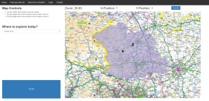
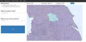
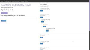
The result is a functional, although not particularly optimised solution, for exploring the 100,000’s of data points within OS Open Greenspace [4]. As an extension, I also generalised the database loader to allow for external open-source locations, such as from the National Trust [5] of English Heritage [6], to also be explored. Users can search for locations by name or narrow down what type of location and where it is, by using place location filters and the OS Boundary data [7]. Once they find a location, they can also get directions from their own address via linking to google maps. The final addition was adding some basic social media type functions, such comments and favourites, to make having a user account mean something, rather than just an authentication system for the sake of having one.  

If I was to start this again, I would certainly do things slightly differently, but as you gain more experience, that’s usually the way of things. This has certainly been an interesting experiment, which will certainly help my own research aims. If possible, I may further this product further into an actual release, to try to make it a deliverable, but given other work commitments that’s not too likely in the immediate future. If you, for whatever reason, want to do that, then 100% of the code I have written is open source and on GitHub [8], and can be used however you want. If you’re brand new to Django, or just want to play around, there is also a YouTube video I made on ‘how’ to build it here [9].  

[1]: https://getoutside.ordnancesurvey.co.uk 

[2]: https://stackoverflow.com/questions/52576376/how-to-zoom-in-on-a-complex-svg-structure 

[3]: https://www.thinkwithgoogle.com/intl/en-gb/marketing-strategies/app-and-mobile/mobile-page-speed-new-industry-benchmarks/ 

[4]: https://osdatahub.os.uk/downloads/open/OpenGreenspace 

[5]: https://open-data-national-trust.hub.arcgis.com/ 

[6]: https://historicengland.org.uk/listing/the-list/data-downloads/ 

[7]: https://osdatahub.os.uk/downloads/open/BoundaryLine 

[8]: https://github.com/sbaker-dev/ToTheGreatOutDoors 

[9]: https://www.youtube.com/watch?v=XnjFhzfCdsE 


An Interview with Widening Participation Intern, Jacob McLaughlin

What did you enjoy about the internship?

I had the opportunity to work on an interesting original project and to gain an insight into how research is conducted at the University. The JGI is a friendly team and the people there are working on a range of interesting things, while the interdisciplinary nature of the project meant there was always lots to learn and various different angles to explore. The wider Widening Participation programme was well-run and I had the opportunity to interact with interns from different departments working on a range of interesting projects.

What did you learn and what skills do you think you developed?

I learned a lot about how the wider University community operates, and about the procedures and processes involved in conducting original research. The project also enabled me to develop both new and existing technical skills, as the work involved creating documentation using tools such as Git and Jupyter Notebook, as well as using Python to conduct analysis. The project I was working on concerned using routine NHS data to predict stroke outcomes, so I also learned more than I expected about medical imaging and the NHS’s data infrastructure!

How has the experience added to your learning with respect to your degree programme?

The technical skills I developed during my internship have been useful during my degree, especially during my Year 3 Data Science module where knowledge of software such as GitHub and added experience using tools such as Python has given me a big head start. In addition, the internship enabled me to improve my research and analytical skills, which has been useful in my degree programme in a wide range of situations. The project also required me to summarise technical information to a variety of people, which has been useful in helping me to convey concepts clearly during my degree programme.

Would you recommend an internship with the JGI and why?

I would definitely recommend an internship with the JGI, as there is a friendly and welcoming atmosphere with plenty of support available. The JGI works on a number of diverse and interesting projects, so it is a great opportunity to utilise and improve your data expertise while simultaneously researching a novel subject. Moreover, getting involved with the JGI and the work they do gives a great insight into how the University works and how research is conducted, which is useful whether you are considering a career in research or not!

An Interview with JGI Intern, Debby Olowu

An Interview with JGI Intern, Debby Olowu

Hi, my name is Debby. Currently, I am a 3rd-year Psychology with Innovation student at the University of Bristol. Earlier this year, for one of my Innovation modules, I was required to complete and write about an internship I took part in. I was privileged that the Jean Golding Institute (JGI) were able to support me in completing an internship for which I am incredibly grateful. Here, I will explain what I learnt from this internship and how it added to my learning.

What did you enjoy about the internship?

I enjoyed learning how the university operates behind the scenes. I particularly enjoyed their biweekly meetings where everyone goes around and introduces themselves and what they have been up to over the past week. This made me feel extremely comfortable because I could get insight into what everyone had been up to, and this made me feel incredibly involved. I also felt less pressure when giving my presentation because I had already met everyone the meeting before. I also enjoyed learning and tackling new projects which were investigating the National AI Strategy and Data Science for primary school students.

What did you learn and what skills do you think you developed?

I learned much from my internship here at the JGI. The biggest thing I learned from this internship was the national AI strategy. This is the government’s 10-year plan to become an AI powerhouse and improve AI across the country. The government has three main aims: the first is to provide the best of the best to work with AI. The second is to implement AI in different sectors such as the NHS. Finally, the last aim is to show people that AI is trustworthy. I did not know much about AI before researching this strategy, but now, I have learned so much about AI. Another thing I learned was about how the primary school and secondary school curriculum integrates data science and artificial intelligence. It was interesting to see the impact data science has on both curricula, but its impact is rarely acknowledged explicitly to students. Data science takes place in so many subjects: ones that most people would be aware of are sciences and maths. However, I was surprised to know that data science can also be incorporated into subjects such as geography and history. Yet, I believe the government should work harder to incorporate data science in the curriculum and to assess it better and originally this was done in coursework but due to significant levels of plagiarism, they had to stop. However, from my research, I feel that data science should be a separate subject to be studied so that students can understand its impact better and be prepared for when it is incorporated into their studies at university.

How has the experience added to your learning with respect to your degree programme?

As mentioned before, for one of my modules in my degree, I had to complete an independent internship module. The JGI not only allowed me to do this but to also improve the skills I use in assessments. This experience enabled me to improve my research and presentation skills. These are essential to my degree as to do well I must be able to research well, and this should strive to be in a way that is engaging yet informative.

Would you recommend an internship with the JGI and why?

I would recommend an internship with JGI especially if you are interested in a career in data science. Even though I am interested in a career in Psychology, conducting projects that require intense research and evaluating whether approaches were beneficial is a necessary aspect of any career, especially Psychology. This shows how doing an internship with the JGI will benefit and aid you, even if you are still deciding on a career path.

I am grateful for the opportunity to work at the JGI and especially to Emma Kuwertz for supporting me throughout my placement!

Turing Interest Groups – New groups launched

Turing Interest Groups – New groups launched

The Alan Turing Institute is pleased to announce that nine new Interest Groups have been launched in October 2022.

Interest Groups aim to promote research collaboration, share knowledge, and communicate emerging scientific concepts to the wider Institute and beyond, around a shared area of interest in data science and AI. In July 2022, a call for new Interest Groups was launched and the response was very positive, receiving a high number of applications from across the University partners, including the Turing University Development Award universities.

The selected Interest Groups cover a wide range of areas of research from theoretical and methodological areas to applications on biodiversity, health and space.

Please visit the Interest Groups webpages to learn more and to find out more information about joining.

The Interest Groups launched in 2022 are: